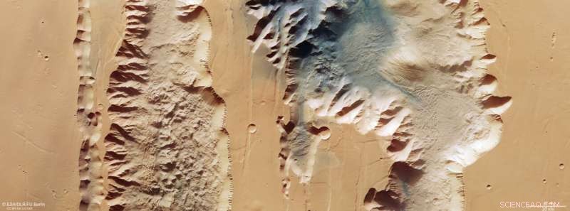
Esta imagen del Mars Express de la ESA muestra a Ius y Tithonium Chasmata, que forman parte de la estructura del cañón Valles Marineris de Marte. Esta imagen comprende datos recopilados por la cámara estéreo de alta resolución (HRSC) de Mars Express el 21 de abril de 2022. Se creó utilizando datos del canal nadir, el campo de visión alineado perpendicularmente a la superficie de Marte y los canales de color del HRSC. . Es una imagen de 'color verdadero', que refleja lo que vería el ojo humano si mirara esta región de Marte. La resolución terrestre es de aproximadamente 25 m/píxel y la imagen está centrada a unos 272°E/6°S. El norte está a la derecha. Crédito:ESA/DLR/FU Berlín, CC BY-SA 3.0 IGO
La última imagen publicada por Mars Express de la ESA nos muestra dos rupturas en la corteza marciana que forman parte del poderoso sistema de cañones Valles Marineris.
Valles Marineris atraviesa Marte como el Gran Cañón atraviesa los Estados Unidos, excepto que este último es minúsculo en comparación. Con 4000 km de largo, 200 km de ancho y hasta 7 km de profundidad, Valles Marineris es casi diez veces más largo, 20 veces más ancho y cinco veces más profundo que el Gran Cañón. Como el sistema de cañones más grande del Sistema Solar, abarcaría la distancia desde el extremo norte de Noruega hasta el extremo sur de Sicilia.
Hay otra gran diferencia entre los dos:mientras que el Gran Cañón se formó cuando el río Colorado erosionó la roca, se cree que Valles Marineris se formó a través de la separación de las placas tectónicas.
La imagen muestra dos trincheras (o chasmas) que forman parte del Valles Marineris occidental. A la izquierda (sur), está el Ius Chasma de 840 km de largo, y a la derecha (norte) está el Tithonium Chasma de 805 km de largo. Si bien estas imágenes de alta resolución muestran un increíble detalle de la superficie, solo cuando miramos un mapa de elevación nos damos cuenta de cuán espectacularmente profundos son los chasmata:¡hasta 7 km! A 4809 m, la montaña más alta de los Alpes, el Mont Blanc, quedaría empequeñecida si se colocara dentro de Tithonium Chasma.
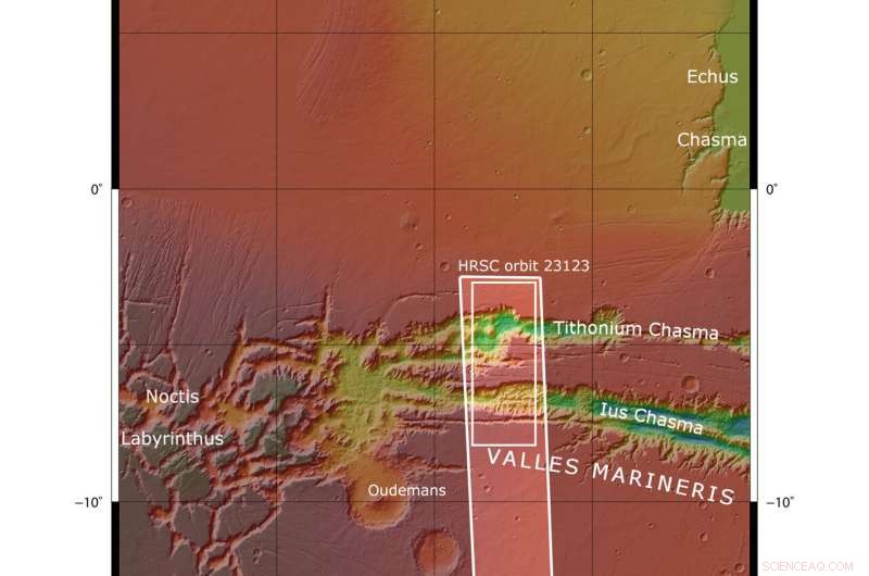
Esta imagen del Mars Express de la ESA muestra a Ius y Tithonium Chasmata, que forman parte de la estructura del cañón Valles Marineris de Marte. El área delimitada por el recuadro blanco en negrita indica el área fotografiada por la cámara estéreo de alta resolución Mars Express el 21 de abril de 2022 durante la órbita 23123. Crédito:Equipo científico de NASA/MGS/MOLA
En la parte superior de Tithonium Chasma, un parche de arena oscura aporta contraste de color a la imagen. This sand may have come from the nearby Tharsis volcanic region.
Next to the dark sand dunes are two light-toned mounds (one cut in half by the upper image border). These "mounds" are more like mountains, rising more than 3000 meters in height. Their surfaces have been strongly eroded by Mars' strong winds, indicating that they are made of a weaker material than the surrounding rock.
Between the two mounds we see a series of smaller bumps, as shown in the second perspective view. Investigations by Mars Express have found water-bearing sulfate minerals in this region. This suggests that these bumps may have formed when liquid that once filled the chasma evaporated, although this theory is still hotly debated.
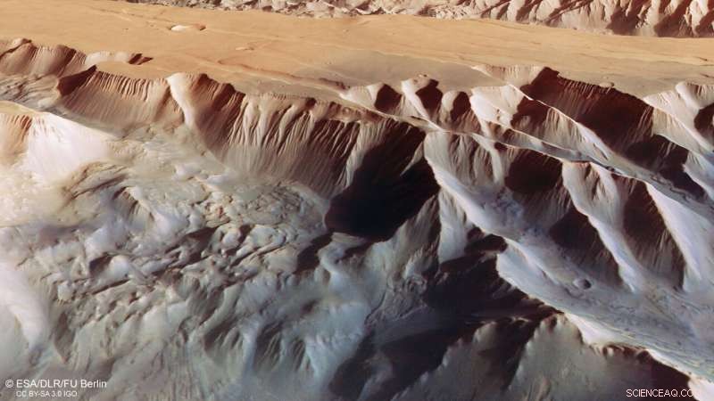
This oblique perspective view of Tithonium Chasmata, which forms part of Mars’ Valles Marineris canyon structure, was generated from the digital terrain model and the nadir and colour channels of the High Resolution Stereo Camera on ESA’s Mars Express. Credit:ESA/DLR/FU Berlin, CC BY-SA 3.0 IGO
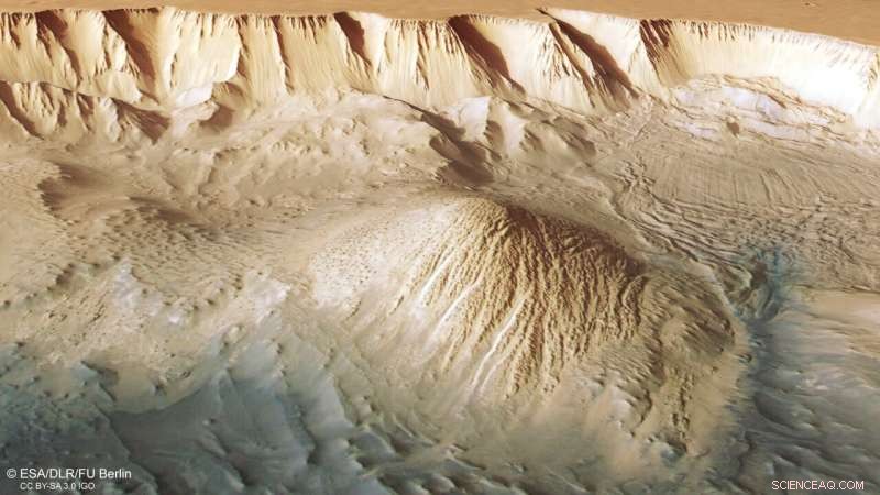
This oblique perspective view of Tithonium Chasmata, which forms part of Mars’ Valles Marineris canyon structure, was generated from the digital terrain model and the nadir and colour channels of the High Resolution Stereo Camera on ESA’s Mars Express. Credit:ESA/DLR/FU Berlin, CC BY-SA 3.0 IGO
To the lower right of the mound that we see fully (upper right in the second perspective view), we can see parallel lines and debris piles that indicate a recent landslide. This is also visible as a large purple area in the topography image below. The landslide was caused by the collapse of the canyon wall on the right, and is likely to have occurred relatively recently because it has not been strongly eroded.
The gnarly floor of Ius Chasma is equally fascinating. As tectonic plates pulled apart, they appear to have caused jagged triangles of rock to form that look like a row of shark teeth. Over time, these rock formations have collapsed and eroded.
Exploring Mars
Mars Express has been orbiting the Red Planet since 2003, imaging Mars' surface, mapping its minerals, identifying the composition and circulation of its tenuous atmosphere, probing beneath its crust, and exploring how various phenomena interact in the Martian environment.
The mission's High Resolution Stereo Camera (HRSC), responsible for these new images, has revealed much about Mars' diverse surface features, with recent images showing everything from wind-sculpted ridges and grooves through impact craters and channels that once carried liquid water to volcanoes, tectonic faults, river channels and ancient lava pools. Image:Layers and fractures in Ophir Chasma, Mars